What on the Site
The duration of the trip: Rivers – a car tour: 50 minutes.
A walking tour: 30 minutes.
Bridgeyard – 45 minutes.
Comments: The entrance to the Old Bridge, to a river site and the Jordan star involves a fee.
Entry into Jordan territory with an ID card.
More about the site.
description of the site
We are ahead of us a visit to Wquot; I" of the Rivers and looking at the power plant of Pinchas Rothenberg, a visit to the Old Bridge site, and an increase to the impressive Crusader needs of the Jordan Star, from which there is a breathtaking view of the Jordan Valley, the exile and the Golan.
on the area
The valley is part of the gate of the Jordan Valley and includes the dock and the mountains in the west and east.
In the north, the baptized bloc of miners descends, and the south extends from the plain of the Jordan Valley, until the encounter between the two rivers, the Jordan River and the Reich.
Access to track
We’re going on a plant road – Beit Han (No. 90).
In front of the entrance to the seat of the Marines, we will turn east to the river site 1 (according to the signage), and reach the visitor center.
The route
The tours on Jordan’s territory in the river are organized by the members of the Amad Yaakov and depart from a river site.
The route mounted to Vquot;i" 1 was made in the site car and includes guidance (for the trip about 50 – minutes) returning through the Rail " the Valley " train; the Hajast train.
Another option: a walk trip to the lake dam, local training.
This is an easy trip that lasts about 30 minutes, and is also intended for small and elderly children.
On the land of emirate from the Jordan River and near the meeting of the Jordan River with the Yarmorich River, the plant was built between 1927 and 1932; the Hannauris " by Pinchas Rothenberg, hence its nickname " the old man from the River "
In order to operate its turbines, the power plant took advantage of the Jordan River and the secretion of the heights between the two river channels.
But only during the winter months when the rivers were abundant, the amount of water needed to run the station was given.
To enable the continued operation in the summer months, it was necessary to lead the Jordan River through a system of dams and canals, to the Great Lake and from us to the electricity plant.
The plant provided a large portion of Israel’s electricity energy to the 1948 War of Independence.
During the war, the place was left, destroyed, and it stands in its residence beyond Jordan.
With the signing of the peace treaty with Jordan, the station was a witness and it became one of the symbols of peace realized.
Since the agreement, the plant of power and all the network of canals, dams and river lakes (which is now dry) can be seen and better view of the factory’s employee living area from Vquot; the island" located in Jordan and is part of the territories that have been leased to Israel under the agreements.
At the entrance to the site, it is possible to see the impressive memorial site in memory of the seven girls from the sunhouse, designed by Orna who are afraid of Jacob.
From the river site, we will go to the Old Bridgeyard and the Battle Museum 3, we will continue on Route 90 to the south, and in the midst of a cross-border bridge east, according to signage.
The beginning of the settlement in 1921.
A group of people " the work-and-quoted battalion; rose to the place to process the surrounding lands bought by Pixar "a.
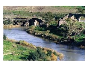
The outposts set on the banks of the Jordan River, near the NATO bridges (an ancient bridge, the railway bridge and the main road bridge).
The Old Bridgeyard tells the history of Jewish settlement in the region with a special emphasis on the battles of the War of Independence, during which the kibbutz stood in the attack of the Jordanian Legion and the focus of the invasion attempts of the Iraqi army.
During the war, the entire bridge was destroyed and rebuilt up the hill, slightly west, and the old courtyard was restored and became an interesting site on the journey to the past.
From the courtyard of a beautiful observation bridge to the Jordan landscape, the Israel-Raden border, the three historic bridges and the Rutenberg power station.
In a bridge garden, a museum operates in underground shelter.
He was the heart of the community during the battles.
In a restored structure of the dining room, a special light-coloured vision is displayed and impressive on the kibbutz and the entire area and the upheavals they have known over the years.
From the bridge we will return to Route No. 90 and we will continue to take a little south to the intersection of the Jordan star.
There we will turn to the right, and the road crossing the Crusader fortress " the Jordan " star.
From the fort there is a spectacular view of the valley of the river, the Jordan Valley, the Golan and the Glad, the gull and the lower Galilee.
The Castle of the Jordan Star is the most complete Crusader fortress in the country.
It was built in the 12th century by the Order of Hesphelers at the highest level of wages, 308 meters above sea level, which are more than 500 meters above the Jordan Valley.
The Crusaders attributed to the place of great importance as it controls the crossings of the Jordan River, the arrival of Damascus.
The name of the fort in French " Balvar " beautiful landscapes, and indeed from all corners of the fort reveal spectacular views.
For the construction of the fortress – built for five years by hundreds of workers and members of the Order – were used stones from an ancient Jewish settlement located in the place.
The name of the settlement is unknown to us, but the decorated synagogue stones, scattered in the walls of the fortress, tell about its past.
In 1189, after a prolonged siege, the place fell into the hands of the Muslims, and was among the last three fortresses that held a position in the face of Muslims after the Battle of Gratin rays in 1187.
Address: Rivers, Crossing a Bridge